Karst Plateaus, Beech Forests, and Island Panoramas: Discover Croatia's Most Beautiful Hiking Trails!
Croatia is renowned not only for its Mediterranean hamlets, azure Adriatic Sea, and sunshine-soaked landscapes but also for its myriad forests and mountains.
Our southern neighbor boasts a plethora of excellently marked, breathtaking hiking trails that meander through karst plateaus, pine woods, and narrow canyons. In this compilation, we present hiking options that vary significantly from one another, yet share the common feature of offering unparalleled experiences and the beauty of nature.
Indeed, our southern neighbor's mainland coastline snakes along the Adriatic Sea for nearly 2000 kilometers. However, when visiting the country, it's advisable to pack not just your swimsuit but your hiking boots as well, as the Croatian mountains have countless experiences to offer.
Near the Hungarian border, in the Drava-Sava region (historically called Slavonia), lie smaller hills, none of which exceed a thousand meters in height. In terms of their wildlife and geological formations, they strongly remind one of the Hungarian mid-mountain ranges.
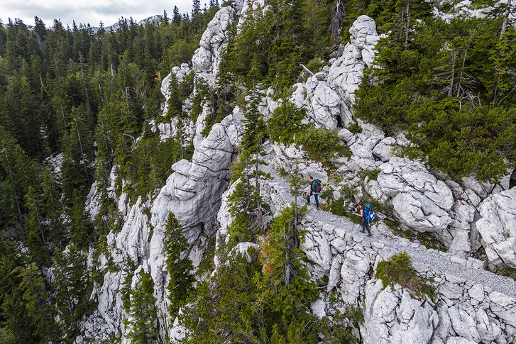
The much vaster areas of the country are occupied by the rugged rocks of the Dinaric Mountains. Stretching from Slovenia to Albania, this limestone mountain range is home to numerous spectacular karst formations. Here, one can admire sinkholes, caves, springs, dolines, and unique rock formations. Averaging 1000-1500 meters in height, here lies Croatia's highest peak, Dinara, soaring to 1831 meters above sea level. The Dinaric Alps support a rich wildlife; wolves, bears, and golden jackals dwell here, primarily amongst Mediterranean pine and oak woodlands at least in places where forests still exist. Throughout the Middle Ages, significant portions of the forest were cleared, initiating erosional processes, preventing the reestablishment of a substantial soil layer on the karst landscape. Thus emerged the barren white rock surfaces that anyone who has visited Croatia would have seen.
Today, Croatia houses eight national parks and countless areas under some form of nature conservation. The country is rich in hiking opportunities, with numerous hiking movements, marked trails, and developed paths. The Croatian Long Distance Trail spans over 2000 kilometers. (For comparison: Hungary's National Blue Trail covers 1173 kilometers.) It stretches from the country's easternmost point, heading towards Muraszentmárton at the northernmost end, then continues to its westernmost point, concluding at Prevlaka, the southernmost part of the country. The Via Adriatica, snaking 1100 kilometers along the seaside, runs from Istria to Dubrovnik. Hiking in Croatia often offers breathtaking views of the sea directly beneath your feet, while other trails promise unique experiences.
In our feature, we recommend five stunning Croatian hikes. Among them are trails suitable even for families with small children, as well as those recommended for more experienced hikers. Some lead to sandy beaches, others meander through the beech forests of Slavonia.
THE SEVEN WATERFALLS TRAIL: A JOURNEY FOR THE ROMANTIC HIKERS
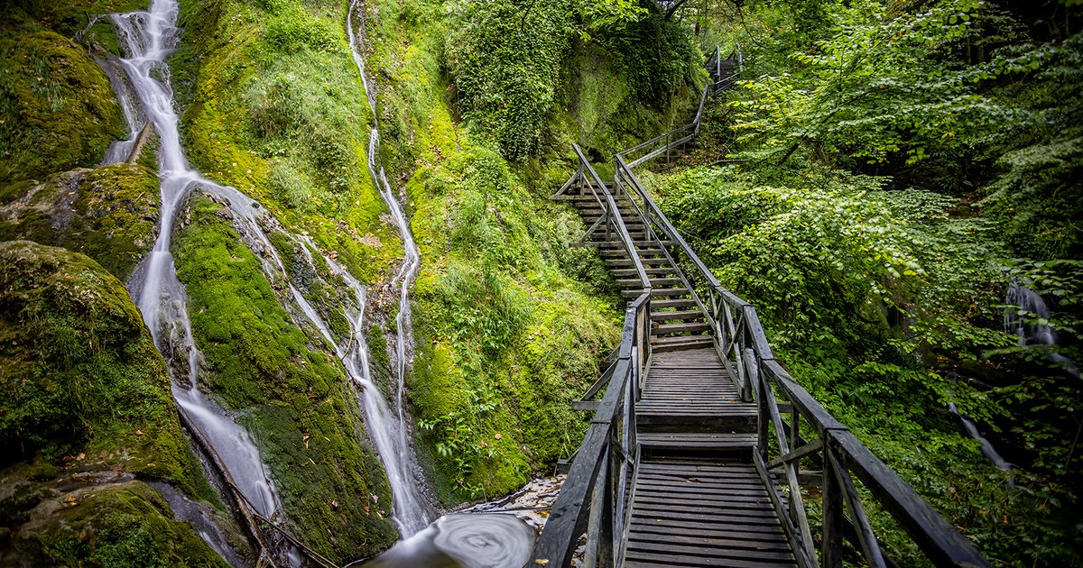
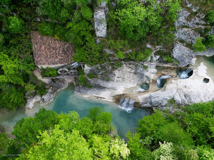
This trail showcases the human-transformed cultural landscape of Istria with its enchanting cascades and picturesque villages. Starting and ending in the small Mediterranean town of Buzet, just a few kilometers from the Slovenian border, the 14-kilometer route follows the Mirna River and its tributary, Draga, weaving through varied limestone formations and surreal blue pools. The highest waterfall along the trail named after it is the Vela peć, where water plunges from a height of 26.5 meters. Legend has it, locals are recognized by their loud speaking, a trait acquired to overpower the roar of the cascades. The path is easily navigable, though a steep, stair-transformed ascent leads up to Greben rock, secured with wire ropes. The trail is accessible in both directions, but it's advisable to approach this segment from below.
During the Seven Waterfalls hike, the path reveals old stone cottages covered in ivy, eventually reaching the village of Kotli. Here, a canyon houses a series of watermills built from the area's white rocks, powered by the tumbling waters of the Mirna River. Another highlight is the 19th-century Napoleonic Bridge. Though the corsair himself never traversed it, the bridge was named for the era of French rule over Istria.
GOLDEN HORN BEACH TRAIL: FOR THOSE WISHING TO DIP INTO THE SEA AT JOURNEY'S END
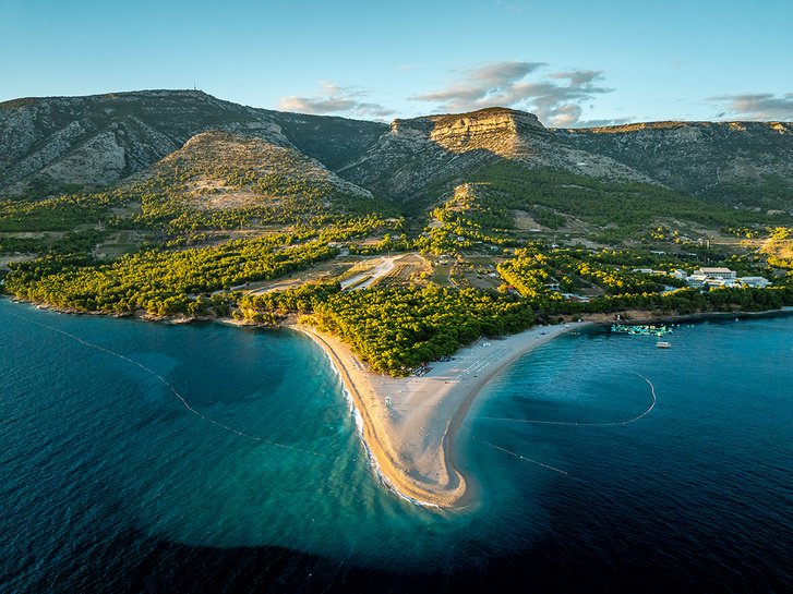
Opposite the city of Split lies the island of Brač, home to one of Croatia's most photographed beaches, the Golden Horn (Zlatni Rat). The beach's shape, covered in white pebbles and edged by Mediterranean pine forests, constantly shifts under the influence of tides and winds. Towering above it is Vidova Gora, at 778 meters not just the tallest point of Brač but of all the Croatian islands.
A two-kilometer trail leads up to the summit from the town of Bol, descending towards the Golden Horn. The journey is accompanied by pine forests and the characteristic white rocks of Brač Island (parts of the White House in Washington D.C. are constructed from these). A stone cross stands at the peak, as is common in many Catholic countries, with the remains of the chapel dedicated to St. Vid 100 meters below. The highest point offers a breathtaking view, making it feel as if the entire Adriatic Sea lies at our feet. For fans of extreme sports, rock climbing routes also lead to the summit, making Vidova Gora a noted destination.
THE PREMUŽIĆ TRAIL: A PATH FOR THOSE SEEKING A CHALLENGE
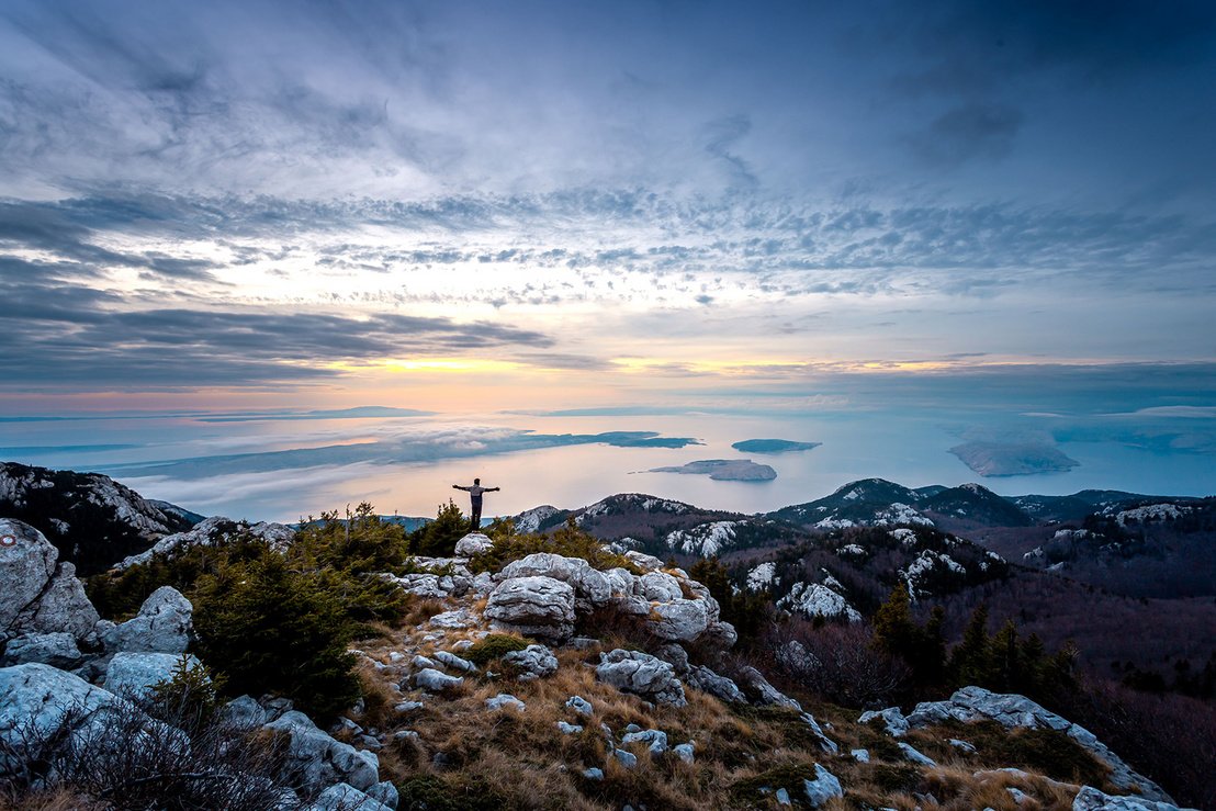
Requiring good physical fitness, this trail reveals the beauties of the Velebit mountain range, the longest stretch of the Dinaric Alps, to explorers. Named after the mountaineer Ante Premužić, the 57-kilometer trail cuts through the Northern Velebit National Park among others. It trails across a plateau, thus avoiding steep climbs or challenging descents. Its safety and lack of exposed, vertiginous sections add to its appeal, its length providing the primary challenge. Often traversed over two to three days by those opting to explore the Dinaric Alps' wonders, camping is prohibited along the trail, though bivouac shelters and mountain huts are available, catering to varying comfort needs.
The journey traverses karst landscapes, touching upon the unique karst formations and underground cave systems of Rožanski Kukovi. The area's charm includes trees bent into peculiar shapes by the weight of snow. Rich in flora and fauna, lucky hikers might encounter deer and chamois. The trail runs parallel and close to the Adriatic Sea, offering stunning views over the Croatian archipelago.
THE LAND ART TRAIL: A PARADISE FOR ART ENTHUSIASTS
The introduction to this journey rightly starts with an art historical overview. Emerging in the 1960s in America, land art integrates artistic creations within natural settings forests, fields, enforcing the unity between the work and its environment. Changes induced by wind, sunshine, or rain are not seen as destructive but as integral to the artistic concept. Considering cave paintings as its precursor, land art insists on using only natural materials.
These principles guided Boris Pecigoš when he conceived his project to highlight the relationship between humans and nature. Established in 2016 within Učka National Park, the Land Art Trail spans just 6.5 kilometers, offering an easily navigable loop even for families with children. The trail features twenty artworks, including rock paintings and stone-laid labyrinths, seamlessly blending into the natural beauty of the Ćićarija mountains.
THE JANKOVAC CIRCULAR TRAIL: FOR THOSE WISHING TO DISCOVER SLAVONIA
Venturing into the Papuk Mountains, located between the Drava and Sava rivers, introduces explorers to a world distinct from the karst plateaus of the Dinaric Alps. But, for nature lovers, visiting the Croatian territories near the Hungarian border is equally rewarding. Once referred to as the “Black Mountain,” this region was famously mentioned in the tales of the “Captain of Tenkes,” recounting the capture of a wolf “beyond, in the Black Mountains.” The area's splendor is best discovered through a moderately challenging circular hike.
Starting and ending at the Jankovac mountain lodge parking area, after covering 13.5 kilometers, the trail's highest point is Ivačka Glava, rising to 913 meters above sea level. Yet, the most impressive vista along the route unfolds from the Nevoljaš lookout, where, in clear weather, the silhouettes of the Mecsek Mountains can be discerned in the distance. The trail is lined with beech trees and ferns, with an abundance of wild garlic sprouting in the spring. Memorials to Croatia's somber history also dot the path; the Anđina Baraka saddle's eleven metal pillars memorialize eleven soldiers who fell during the Yugoslav Wars, while a small detour reveals a secluded Partisan cemetery in the forest's depths.
This route can be combined with a visit to the ‘Count’s Path’ educational trail. Named after Count József Jankovics, who returned from Vienna in the early 19th century to devote his life to the prosperity of the region, the aristocrat's final resting place lies within a cave along the path.
Indeed, our southern neighbor's mainland coastline snakes along the Adriatic Sea for nearly 2000 kilometers. However, when visiting the country, it's advisable to pack not just your swimsuit but your hiking boots as well, as the Croatian mountains have countless experiences to offer.
Near the Hungarian border, in the Drava-Sava region (historically called Slavonia), lie smaller hills, none of which exceed a thousand meters in height. In terms of their wildlife and geological formations, they strongly remind one of the Hungarian mid-mountain ranges.
The much vaster areas of the country are occupied by the rugged rocks of the Dinaric Mountains. Stretching from Slovenia to Albania, this limestone mountain range is home to numerous spectacular karst formations. Here, one can admire sinkholes, caves, springs, dolines, and unique rock formations. Averaging 1000-1500 meters in height, here lies Croatia's highest peak, Dinara, soaring to 1831 meters above sea level. The Dinaric Alps support a rich wildlife; wolves, bears, and golden jackals dwell here, primarily amongst Mediterranean pine and oak woodlands at least in places where forests still exist. Throughout the Middle Ages, significant portions of the forest were cleared, initiating erosional processes, preventing the reestablishment of a substantial soil layer on the karst landscape. Thus emerged the barren white rock surfaces that anyone who has visited Croatia would have seen.
Today, Croatia houses eight national parks and countless areas under some form of nature conservation. The country is rich in hiking opportunities, with numerous hiking movements, marked trails, and developed paths. The Croatian Long Distance Trail spans over 2000 kilometers. (For comparison: Hungary's National Blue Trail covers 1173 kilometers.) It stretches from the country's easternmost point, heading towards Muraszentmárton at the northernmost end, then continues to its westernmost point, concluding at Prevlaka, the southernmost part of the country. The Via Adriatica, snaking 1100 kilometers along the seaside, runs from Istria to Dubrovnik. Hiking in Croatia often offers breathtaking views of the sea directly beneath your feet, while other trails promise unique experiences.
In our feature, we recommend five stunning Croatian hikes. Among them are trails suitable even for families with small children, as well as those recommended for more experienced hikers. Some lead to sandy beaches, others meander through the beech forests of Slavonia.
THE SEVEN WATERFALLS TRAIL: A JOURNEY FOR THE ROMANTIC HIKERS
This trail showcases the human-transformed cultural landscape of Istria with its enchanting cascades and picturesque villages. Starting and ending in the small Mediterranean town of Buzet, just a few kilometers from the Slovenian border, the 14-kilometer route follows the Mirna River and its tributary, Draga, weaving through varied limestone formations and surreal blue pools. The highest waterfall along the trail named after it is the Vela peć, where water plunges from a height of 26.5 meters. Legend has it, locals are recognized by their loud speaking, a trait acquired to overpower the roar of the cascades. The path is easily navigable, though a steep, stair-transformed ascent leads up to Greben rock, secured with wire ropes. The trail is accessible in both directions, but it's advisable to approach this segment from below.
During the Seven Waterfalls hike, the path reveals old stone cottages covered in ivy, eventually reaching the village of Kotli. Here, a canyon houses a series of watermills built from the area's white rocks, powered by the tumbling waters of the Mirna River. Another highlight is the 19th-century Napoleonic Bridge. Though the corsair himself never traversed it, the bridge was named for the era of French rule over Istria.
GOLDEN HORN BEACH TRAIL: FOR THOSE WISHING TO DIP INTO THE SEA AT JOURNEY'S END
Opposite the city of Split lies the island of Brač, home to one of Croatia's most photographed beaches, the Golden Horn (Zlatni Rat). The beach's shape, covered in white pebbles and edged by Mediterranean pine forests, constantly shifts under the influence of tides and winds. Towering above it is Vidova Gora, at 778 meters not just the tallest point of Brač but of all the Croatian islands.
A two-kilometer trail leads up to the summit from the town of Bol, descending towards the Golden Horn. The journey is accompanied by pine forests and the characteristic white rocks of Brač Island (parts of the White House in Washington D.C. are constructed from these). A stone cross stands at the peak, as is common in many Catholic countries, with the remains of the chapel dedicated to St. Vid 100 meters below. The highest point offers a breathtaking view, making it feel as if the entire Adriatic Sea lies at our feet. For fans of extreme sports, rock climbing routes also lead to the summit, making Vidova Gora a noted destination.
THE PREMUŽIĆ TRAIL: A PATH FOR THOSE SEEKING A CHALLENGE
Requiring good physical fitness, this trail reveals the beauties of the Velebit mountain range, the longest stretch of the Dinaric Alps, to explorers. Named after the mountaineer Ante Premužić, the 57-kilometer trail cuts through the Northern Velebit National Park among others. It trails across a plateau, thus avoiding steep climbs or challenging descents. Its safety and lack of exposed, vertiginous sections add to its appeal, its length providing the primary challenge. Often traversed over two to three days by those opting to explore the Dinaric Alps' wonders, camping is prohibited along the trail, though bivouac shelters and mountain huts are available, catering to varying comfort needs.
The journey traverses karst landscapes, touching upon the unique karst formations and underground cave systems of Rožanski Kukovi. The area's charm includes trees bent into peculiar shapes by the weight of snow. Rich in flora and fauna, lucky hikers might encounter deer and chamois. The trail runs parallel and close to the Adriatic Sea, offering stunning views over the Croatian archipelago.
THE LAND ART TRAIL: A PARADISE FOR ART ENTHUSIASTS
The introduction to this journey rightly starts with an art historical overview. Emerging in the 1960s in America, land art integrates artistic creations within natural settings forests, fields, enforcing the unity between the work and its environment. Changes induced by wind, sunshine, or rain are not seen as destructive but as integral to the artistic concept. Considering cave paintings as its precursor, land art insists on using only natural materials.
These principles guided Boris Pecigoš when he conceived his project to highlight the relationship between humans and nature. Established in 2016 within Učka National Park, the Land Art Trail spans just 6.5 kilometers, offering an easily navigable loop even for families with children. The trail features twenty artworks, including rock paintings and stone-laid labyrinths, seamlessly blending into the natural beauty of the Ćićarija mountains.
THE JANKOVAC CIRCULAR TRAIL: FOR THOSE WISHING TO DISCOVER SLAVONIA
Venturing into the Papuk Mountains, located between the Drava and Sava rivers, introduces explorers to a world distinct from the karst plateaus of the Dinaric Alps. But, for nature lovers, visiting the Croatian territories near the Hungarian border is equally rewarding. Once referred to as the “Black Mountain,” this region was famously mentioned in the tales of the “Captain of Tenkes,” recounting the capture of a wolf “beyond, in the Black Mountains.” The area's splendor is best discovered through a moderately challenging circular hike.
Starting and ending at the Jankovac mountain lodge parking area, after covering 13.5 kilometers, the trail's highest point is Ivačka Glava, rising to 913 meters above sea level. Yet, the most impressive vista along the route unfolds from the Nevoljaš lookout, where, in clear weather, the silhouettes of the Mecsek Mountains can be discerned in the distance. The trail is lined with beech trees and ferns, with an abundance of wild garlic sprouting in the spring. Memorials to Croatia's somber history also dot the path; the Anđina Baraka saddle's eleven metal pillars memorialize eleven soldiers who fell during the Yugoslav Wars, while a small detour reveals a secluded Partisan cemetery in the forest's depths.
This route can be combined with a visit to the ‘Count’s Path’ educational trail. Named after Count József Jankovics, who returned from Vienna in the early 19th century to devote his life to the prosperity of the region, the aristocrat's final resting place lies within a cave along the path.
Translation:
Translated by AI